One if by Land . . . Two if by Sea
Today is going to be a little different pace than
yesterday. Zac Brown’s “I ain’t in no
hurry today” is the theme. Got up, made
coffee with my Bailey’s to set the morning since it was slightly chilly about
fifty degrees. Hit the road about 9:40
AM driving south down Hwy 1.
You could see the fog bank off shore several miles and it
seemed to be inching closer to the coast as I drove. It was a very pretty drive with the road
winding its way along the coast climbing up and down several thousand feet from
sea level up the mountains. Driving the
coast is not a fast way to travel with average speeds about 35 to 45 mph. There are stretches that 55 is the speed
limit but it is hard to maintain any speed as you slow down for the curves
posted at 30, 20, or 15 mph.
I drove about an hour past one of the places I was thinking
about camping, Navarro Beach where the redwoods state park is just a few miles
away. As I climbed up one of the cliffs
from the beach area there was a pretty steep incline as I noticed a lone
bicyclist walking his bike up this steep grade?
He was about 2/3 of the way up as I spotted a small pull off about 700
feet above him so I quickly pulled off.
It was a great picture taking opportunity as I waited for him to reach
me. I took several photos with my camera
and iphone as he pulled up to where I had stopped. I handed him a cold bottle of water and
greeted him and we started talking. John
was from South Africa and started his bicycle ride in Vancouver BC and was on
his way to LA. We talked for a bit
before I headed off onto other vistas.
I passed by the Organic Valley Farms close to Manchester
CA. It was interesting to see everyone working
the fields and the logo on everything around the area.
I stopped around 11 AM at Lighthouse Point Arena to take
photos of the lighthouse and the beautiful rocks and waves crashing onto them
below the cliffs. As you travel down
this coastal highway it is easy to stop multiple times to take photographs of
the rock formations in the ocean. At one
point today I had to tell myself, just how many rock/ocean/wave photos does one
need to take? There are just rocks, some
with holes in them creating a tide pool splashing through as the waves break on
the rocks. Some “rocks” are a big as a
small city block several hundred feet long and ten stories tall or more.
The fog layer was rolling in along the coast so I figured it
would be a long day driving in the grey soup weather but it only lasted a few
miles and cleared up. The fog band was
just offshore most of the day with small bands of fog that came ashore. It
turned out better than I was expecting with only brief periods of fog to deal
with.
I should have gotten fuel at the morning start but figured I
would get something along the way. Well
on this roadway there are few places for any services much less gas
stations. I had almost 400 miles on this
tank of fuel and was just starting to debate the five gallons of fuel on my
roof and whether or not it would be needed. I pulled into a small community by
the ocean called Gualala and several services.
The Exxon station was there so I pulled in and started pumping my
gas. Yes this is not Oregon and had to
do it all myself. They know they have
you as the price was $3.05 a gallon.
$72.00 later my tank was full having pumped almost 23 gallons into a 22
gallon tank. I probably would have been
walking or pulling off the five gallons I have carried since Anchorage Alaska
for emergencies.
Just past Jenner by the Sea was a small state park called
Goat Rock where off in the distance I saw a lone hang glider pilot soaring over
the cliffs. I went through Jenner and
past the tidewater marsh and started climbing up along the ridge line. I found the cut off to the beach and the park
and drove several miles to get to the cliff where the glider pilot
launched. There was a guy working on his
paraglider chute but he has not anywhere close to preparing for takeoff. I took some photos, a video and had another
cup of coffee while watching him make his turns go out away from the cliff face
to the front edge of the lift band and watch him lose altitude then turn back
towards the cliff into the lift band again rising up over the take off point.
There were several neat places along the way; Duncan’s cove
(I thought a great title for a book), Bodega Bay where I stopped for fresh
oysters and also tried the BBQ oysters both were excellent at Nick’s Cove
Seafood.
I was making my way toward another lighthouse out on Point
Reyes Station. It was a rough road drive the 20 or so miles out to the cliff
where the lighthouse was. Not worth the drive or the bumps in the road as it
was about a two and a half hours round trip out and back. It was totally fogged
in so there was nothing to see. On the
way out I passed several working farms with cattle open grazing along the
road. I saw three deer on a hill above
me grazing. They looked up but continued
to eat. I noticed after almost an hours
drive out there was a sign saying the lighthouse was closed Tuesday, Wednesday,
and Thursday. I know there are a lot of
mad people driving all that way only to find out it is closed. They need to put the sign as you leave town
so you can turn around. With the fog,
bumpy roads and miles of “historical farms” along the way I didn’t think it was
worth the drive.
I stopped briefly in San Rafael for ice and a quick bite to
eat and realized all the curves had shifted my top pod, cooler, and gas tank on
my roof. It had slid slightly over the
side of the driver’s side of the vehicle so I had to push everything back up
where it belonged and then retighten all the u-bolts holding the wood rack to
the car top rack. There were too many
curves, quick stops and shifting left and right over the last two days driving
along the coast.
Right at six PM Placido Flamingo and I were heading across
the Golden Gate Bridge into San Francisco.
We were going in the right direction as those going over to Marin County
were bumper to bumper stopped traffic. I
noticed the tunnel leading off Marin and to the Bridge was named for Robin
Williams who grew up there. There were many people on the side of the bridge on
both sides riding bicycles, walking or jogging across. I was totally surprised just how many were on
the walk paths on each side.

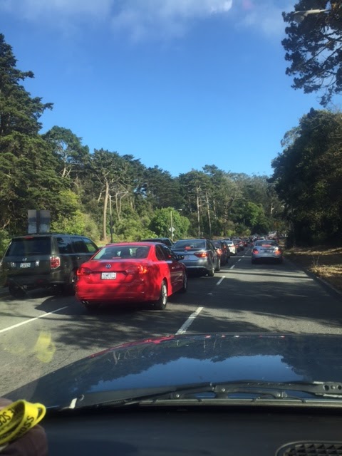
After crossing the bridge I turned quickly off at the Presidio
and through Daly City. Traffic was back up and took about thirty minutes to go just several miles. It is a large Asian
community close to the college, SFSU.
Through Pacifica and back onto CA 1 to Half Moon Bay where the fog
rolled back in again.
Since I have been in California it is very noticeable how
many Toyota Prius vehicles driving around.
They are everywhere. I did
several counts and it was averaging about 1 Prius for every 7 vehicles passing
by. Many times it was one out of three.
I stopped at one last lighthouse before Santa Cruz called
Pigeon Point Lighthouse and hostel. I
debated staying there and not camp but decided to continue toward Santa Cruz
for the night.


Tomorrow after some place to hit in the morning I am
changing up my plans from my original thoughts.
I am not going to continue to Los Angeles and points south on CA 1. I debate Palm Springs at 110 degrees right
now and my plans to hike in Joshua Tree NP.
We will see what tomorrow brings . . . around the bend in
the road.
Ice


Comments